CISA Warns of Hurricane/Typhoon-Related Scams

The Cybersecurity & Infrastructure Security Agency (CISA) urges users to remain on alert for malicious cyber activity following a natural disaster such as a hurricane or typhoon, as attackers target potential disaster victims by leveraging social engineering tactics, techniques, and procedures (TTPs). Social engineering TTPs include phishing attacks that use email or malicious websites to solicit personal information by posing as a trustworthy organization, notably as charities providing relief. Exercise caution in handling emails with hurricane/typhoon-related subject lines, attachments, or hyperlinks to avoid compromise. In addition, be wary of social media pleas, texts, or door-to-door solicitations related to severe weather events.

CISA encourages users to review the Federal Trade Commission’s Staying Alert to Disaster-related Scams and Before Giving to a Charity, and CISA’s Using Caution with Email Attachments and Tips on Avoiding Social Engineering and Phishing Attacks to avoid falling victim to malicious attacks.

IRC warns damaged infrastructure is hampering critical aid supply to catastrophic disaster as it launches emergency response

As the full scale of the disaster in Syria and Turkey following the 7.8 magnitude earthquake becomes apparent, the International Rescue Committee (IRC) is warning of catastrophic humanitarian needs in both countries. Unfettered humanitarian access to those affected is now absolutely critical. As humanitarian needs soar during freezing temperatures, in both Turkey and Syria, the IRC is launching an integrated response to affected populations in both countries.

Tanya Evans, Syria Country Director for IRC said:

“The scale of the disaster is catastrophic. We are still in the first 36 hours of one of the largest earthquakes to hit the region this century. Multiple earthquakes and aftershocks yesterday and today have damaged roads, border crossings, and critical infrastructure, severely hampering aid efforts.

“IRC’s main priority is finding safe spaces for our staff to operate from in Gaziantep and across northwest Syria. Many buildings have been severely damaged in the earthquake, including at least one of our field offices in northwest Syria. It is almost impossible to know the full extent of the disaster right now but everything we are hearing from our teams suggests it is truly devastating.

“Electricity across the affected area remains intermittent. In Turkey we have seen improvements since the earthquake but in northern Syria there are still so many areas off the grid. This also includes mobile and internet outages making the response and coordination even more difficult. It is not just electricity and phone lines affected. Gas supplies, for which many rely on to heat their homes, have also been severely impacted meaning that even if people are able to return to their homes they will have to endure freezing temperatures.

“With the response in its infancy the need for humanitarian aid is stark. Roads and infrastructure, like bridges, have been damaged meaning it will likely prove challenging to get supplies to those who need it most. Even before the earthquake, humanitarian access was constrained in northwest Syria, with most aid coming in via one crossing point with Turkey. In this time of increased need it is critical that the levels of aid crossing also increase at pace too.”

The IRC’s response to the earthquake will be in both Turkey and northern Syria, and will include the provision of immediate cash, basic items such as household kits, dignity kits for women and girls and hygiene supplies. Through partners, the IRC will support essential health services in earthquake-affected areas, and set up safe spaces for women and children affected by the crisis.

In light of the catastrophic humanitarian needs emerging, the IRC is calling on the international community to urgently increase critical funding to both Syria and Turkey to ensure that those affected by this emergency get the lifesaving support they need before it is too late.

[image: DENIZ TEKIN/EPA-EFE/Shutterstock]

USDA invests more than $698,000 in critical infrastructure to combat climate change

The U.S. Department of Agriculture announced this week that USDA Rural Development will invest more than $698,000 in critical infrastructure to combat climate change across rural Missouri.

Among the funded projects is Macon Coca-Cola Bottling Company's installation of a 46.98 kilowatt solar array system. The company will use a $20,000 Rural Energy for America Program grant to replace 71,831 killowatt hours (100% of the company's energy use) per year, saving the company more than $6,000.

The investments reflect the goals of President Biden’s Inflation Reduction Act, which addresses immediate economic needs and includes the largest ever federal investment in clean energy for the future, the USDA said.

For example, the Act includes $14 billion in funding for USDA programs that support the expansion of biofuels and help rural businesses and electric cooperatives transition to renewable energy and zero-emission systems.

USDA is making these investments through Community Facilities Disaster Grants, Rural Energy for America Program Renewable Energy Systems & Energy Efficiency Improvement Guaranteed Loans & Grants, and Rural Energy for America Program Energy Audits and Renewable Energy Development Grants.

Southeast Asia Flash Flood Guidance System Launched

The Southeast Asia Flash Flood Guidance System (SeAFFGS) has been officially launched, ushering in the prospect of improved early warnings for a major natural hazard, which accounts for a significant portion of the lives lost and property damages due to flooding in the region.

Under a new agreement, the SeAFFGS will be operated by the Viet Nam Meteorological and Hydrological Administration (VNMHA), which is providing effective flash flood guidance and forecasts within Viet Nam and will act as the regional center covering Cambodia, Lao PDR, and Thailand, providing forecast products, data, and training.

The new regional centre will strengthen the World Meteorological Organization’s global Flash Flood Guidance System network, which now covers 67 countries and is a key plank in WMO’s campaign to ensure that Early Warning services reach everyone in the world in the next five years.

Flash floods claim the lives of thousands of people every year and have big social, economic and environmental impacts. Southeast Asia has a tropical monsoon climate and is one of the regions heavily affected by hydrological disasters such as flood, flash floods and landslides. It has long been recognized that the development and implementation of a flash flood forecasting system would greatly enhance public safety.

Accurate and timely warning of flash floods enables the mandated national authorities to undertake appropriate measures, thereby supporting them to protect the population at risk from their disastrous effects.A Memorandum of Understanding was signed at a ceremony at WMO headquarters on 8 August, formally designating VNMHA as the SeAFFGS Regional Centre and underlining mutual commitment to improve hydrological activities and early warnings across Southeast Asia.

“After 5 years of hard works and remarkable efforts, a flash flood guidance system in South East Asia was officially established which I believe will save a lot of lives and reduce significant damage cost for the region. The MOU signing ceremony today marks a very important milestone for the Southeast Asia community in general and for Vietnam in particular to enhance resilience to disasters,” said Professor Tran Hong Thai, VNMHA Administrator.

Dr Wenjian Zhang, Assistant Secretary-General of WMO said the Regional Centre would play a critical role in the overall functioning of the SeAFFGS project, strengthening collaboration and increasing the capacity of participating National Meteorological and Hydrological Services to provide timely and accurate forecasts and warnings of hydrometeorological hazards. He spoke on behalf of WMO Secretary-General Prof. Petteri Taalas.

The SeAFFGS has been developed under the project “Building Resilience to High-Impact Hydrometeorological Events through Strengthening Multi-Hazard Early Warning Systems (MHEWS) in Small Island Developing States (SIDS) and Southeast Asia (SEA)”, which is funded by the Government of Canada (Environment and Climate Change Canada – ECCC), and implemented by the World Meteorological Organization and the Hydrologic Research Center (HRC), while National Oceanic and Atmospheric Administration (NOAA) is a satellite data provider into the System.
Flash flood guidance system for Southeast Asia

Following the signing of the MoU, the Regional Centre now carries the responsibility of, maintaining the server used for SeAFFGS and securing File Transfer Server to exchange data and information, provision of capacity-building initiatives and to facilitate effective coordination among members involved in SeAFFGS.

Flash floods differ from river floods in their short time scales and occurrence on small spatial scales, which makes flash flood forecasting a different challenge from large-river flood forecasting. In flash floods forecasting, we are concerned foremost with the forecast of occurrence, and herein focus on two causative events: 1) intense rainfall; and 2) rainfall on saturated soils. Flash floods occur throughout the world, and the development times vary across regions from minutes to several hours depending on the land surface, geomorphological and hydrometeorological characteristics of the region. However, for the majority of these areas, there exists no formal process or capacity for developing flash flood warnings.

New open-source software that decrypts social media messages to help manage risks and disasters

The European Commission’s new algorithm developed by the Joint Research Centre (JRC) can segment social media messages to identify, verify and help manage disaster events -such as floods, fires or earthquakes- in real-time.

Suppose you are an emergency responder and you see a social media post showing an unusable road in a place not covered by traditional news. Suppose you see a similar message from several accounts. Wouldn’t you wonder if they were referring to the same event or whether that area was worth a more detailed analysis with a satellite image?

It was with this in mind that scientists from the JRC helped deal with the 2021 Haiti Earthquake by using social media data analysis to complement the assessment of impacts in the immediate aftermath of the earthquake.

This experience was the first real case usage of a software platform that can scan millions of social media texts and images per day for situational awareness and impact assessment. This information is collected, filtered and geocoded automatically and in real-time using machine learning (artificial intelligence) models.
A software that helps responders with flood risk management

The first goal of this platform was to provide an additional geospatial layer in the European Flood Awareness System (EFASSearch for available translations of the preceding linkEN•••) and the Global Flood Awareness System (GloFAS). These two online systems offer flood forecasts based on model simulations which are crucial to the Copernicus Emergency Management Services Managed by JRC.

The monitoring ability of these early warning systems is mostly anchored in satellite images and numerical models.The integration of this new social media for disaster risk management (SMDRM) software will allow them to assess the likelihood and impacts of a flood event with even greater accuracy.
An open-source tool available to all researchers and technicians

The new layer for EFASSearch for available translations of the preceding linkEN••• and GloFAS is the first product developed using the SMDRM software. Nonetheless, since the software has been released as open-source -free and open to all technicians linked to crisis response who want to leverage it- the scientists expect it to have a wider use and they remain available for collaboration.

The SMDRM software can be adapted for different scales and label relevant images for floods, storms, earthquakes and fires, resulting in valuable information for reports or descriptions of the situation on the ground or in the vicinity.

Technicians or researchers working on map development can use the code to find more data to improve or confirm their findings and complement information extracted from traditional sensors or earth observation sources.
Software that connects citizens to disaster risk management

The SMDRM software data help confirm whether an event is happening and where exactly the most affected locations are.

It is a clear example of how social media and active citizenship can contribute to disaster risk management as it help crisis responders improve their situational awareness in the immediate aftermath of an event.

DOE Should Address Lessons Learned from Previous Disasters to Enhance Resilience

Natural disasters, such as cyclones, earthquakes, hurricanes, wildfires, and severe storms—and the power outages resulting from these disasters—have affected millions of customers and cost billions of dollars. The growing severity of wildfires and extreme weather events in recent years has been a principal contributor to an increase in the frequency and duration of power outages in the U.S. Federal agencies, such as DOE and the Federal Emergency Management Agency, play a significant role in disaster response, recovery, and resilience.

This report (1) identifies lessons learned from federal, state, and other entities' responses to selected disasters that affected the electricity grid from 2017 to 2021; and (2) examines federal agency actions to address those lessons learned. GAO selected a nongeneralizable sample of 15 of 35 disasters that affected the grid from 2017 to 2021. The 15 selected were among the most severe events across a range of types, locations, and years. GAO also examined agency and industry responses; reviewed relevant reports, policies, and documents; and interviewed federal, state, and local officials, as well as selected industry stakeholders.

Power outages caused by natural disasters have affected millions of customers and cost billions of dollars. The Department of Energy plays a key role in disaster response and long-term electricity grid recovery.

DOE has taken some steps to improve its workforce and training, tools and technology, and local capacity to respond to disasters. But, DOE doesn't have a comprehensive plan for coordinating response and recovery responsibilities within the agency. In addition, DOE hasn't used lessons learned from previous disasters to prioritize recovery efforts.

In responding to selected disasters occurring between 2017 and 2021, federal, state, and other stakeholders identified lessons learned in the areas of planning and coordination, workforce and training, tools and technology, and local capacity. In the area of planning and coordination, agency officials and reports highlighted that disaster responses were more effective when strong working relationships existed between federal, industry, and local stakeholders. Regarding workforce and training, a Department of Energy (DOE) report emphasized the importance of having a dedicated pool of responders with expertise in grid reconstruction and recovery, especially when responding to multiple, concurrent or successive disasters.

Federal agencies have taken steps to address lessons learned by improving workforce and training, tools and technology, and local capacity. For example, to address workforce lessons, DOE began deploying a Catastrophic Incident Response Team to quickly bring responders with subject-matter expertise to affected areas. However, DOE does not have a comprehensive approach for coordinating its broader grid support mission that includes disaster response, grid recovery, and technical assistance efforts. Specifically, roles and responsibilities within DOE for transitioning from response to recovery are unclear, as are how lessons learned from previous disasters are used to prioritize recovery and technical assistance efforts. GAO's Disaster Resilience Framework states that bringing together the disparate missions and resources that support disaster risk reduction can help build resilience to natural hazards. By establishing a comprehensive approach that clearly defines roles and responsibilities, and acting on lessons learned across DOE, the department could better target resources and technical assistance. This approach, in turn, can lead to enhanced grid resilience and reduced disaster risk.


How is the Federal Government Approaching Climate Resilience?

Extreme weather events—like wildfires, hurricanes, and some winter storms—threaten the stability of critical infrastructure that we rely on every day. This includes systems like roads, electric grids, supply chains, as well as how this infrastructure is used for military operations. The projected impact of climate change on these critical infrastructures is a key source of federal fiscal exposure because of the size of the federal government’s investment and states’ increasing reliance on the federal government for disaster assistance.

This past year may go on record as one of the most active and costly years for extreme weather events. As of Oct. 8, there have been 18 such events, each with losses exceeding $1 billion, according to the National Centers for Environmental Information. Disaster costs are projected to increase as certain extreme weather events become more frequent and intense due to climate change—as observed and projected by the U.S. Global Change Research Program and the National Academies of Sciences, Engineering, and Medicine.

One way to reduce long-term risk to people and property from natural hazards is to enhance climate resilience. Enhancing climate resilience means taking actions to reduce potential future losses by planning and preparing for potential climate hazards, such as extreme rainfall, sea level rise, and drought. The Administration is taking some actions through various climate-related Executive Orders, and we are monitoring implementation of these emerging efforts.

As our climate continues to change, experts say this trend of larger, more costly weather events will also continue. Today’s WatchBlog post looks at some of our work on federal climate-resilience activities.

Climate-resilient public infrastructure

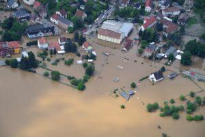
Every year, the federal government spends billions of dollars to maintain buildings, levees, and roads. This cost could grow as certain weather-related events that cause damage increase in frequency and intensity.

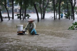
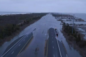
For instance, if roads are flooded from dangerous amounts of rainfall or hurricanes, routes used for emergency evacuations can become unsafe and require costly repairs. Road damage due to climate-related changes may even cost up to $20 billion annually by the end of the century, according to the 2018 Fourth National Climate Assessment.

Over the last decade, the Federal Highway Administration (FHWA), which is part of the Department of Transportation (DOT), has developed policies, provided technical assistance, and funded climate-resilience research as part of its efforts to address climate change's impacts on roadways.

In our September report we found that some states were planning, or already made, changes to their infrastructure using FHWA resources. For example, in Maryland authorities raised a bridge by two feet in anticipation of rising sea levels. While some improvements have been made, more can be done to enhance the climate resiliency of federally funded roads. We identified 10 options for DOT to consider. For example, DOT could provide information to states on best practices and how to include climate projections into road planning and design.

DOT agreed to consider our options when prioritizing climate-resilience actions.

Climate-resilient electricity grid

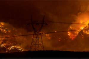
Severe weather is also expected to impact nearly every aspect of the electricity grid—including the generation, transmission, distribution, and demand for electricity. Extreme-weather events could cost billions—from power outages to infrastructure damage—and leave people without access to electricity.

In February 2021, dangerously cold weather spread into Texas causing increased demand for electricity, and about 4.5 million people lost power.

In August 2021, Hurricane Ida resulted in at least a million people, across three states, without electricity and left seven people dead.

How can we better protect the electricity grid?

Although private companies own much of the electricity grid, the federal government is a key player in promoting its resiliency. Since 2014 the Department of Energy (DOE) and the Federal Energy Regulatory Commission (FERC) have taken steps to improve grid resilience, such as partnering with utilities and collecting information on weather-related risks to grid operations. However, DOE still doesn’t have an overall strategy to guide its climate-resiliency efforts despite recognizing the risks. Additionally, FERC hasn’t identified or assessed weather-related risks to the grid.

In a March 2021 report, we recommended that DOE develop a department-wide strategy to enhance grid resilience, and FERC identify and asses risks to the grid and plan a response.

[Source: GAO]

How Parliamentarians can L.A.B.O.R. for disaster resilience

While hazards may be natural, disasters are not. The choices we make can either increase or decrease risk. As the planet slowly warms, parliamentarians can help. Indeed, they can L.A.B.O.R. for resilience.

The global pandemic caused by Covid-19 has been a wake-up call for the whole world. Appalling losses of life, economic devastation and ripples of insecurity have touched every corner of the planet. No one has been immune and the power (or lack thereof) of the state to prevent, prepare and respond has been severely tested. While there’s no way to guess how the pandemic would have unfolded had the world been more prepared, research repeatedly shows that disaster risk reduction and preparedness mitigate losses by large margins. Just 24 hours warning of a coming storm or heat wave can cut the ensuing damage by 30 percent.

As public tolerance for risk is decreasing; citizens around the world are increasingly exposed to growing and compounded risks, with losses now reaching between $250 and $300 billion annually, up from about $50 billion in the 1980s. Climate change interacts with other hazards - technological, biological, chemical and geopolitical, among others – which creates greater risk complexity. The impacts of disaster know no bounds, but those living in more vulnerable circumstances tend to be the hardest hit, with poorer countries registering the highest post-disaster mortality rates.

While hazards may be natural, disasters are not

Flood, earthquakes, landslides or storms become disasters because of the exposure and vulnerability of people and places. The choices we make can either increase or decrease risk. Therefore, each stakeholder has a role in reducing disaster risk. Parliamentarians are uniquely situated to help societies weather all kind of disasters with more resilience and preparation. Last year, the United Nations Office for Disaster Risk Reduction (UNDRR) and the Inter-Parliamentary Union (IPU) launched a toolkit for parliamentarians detailing how they can help build resilience for their communities. The guidance features ten recommendations grouped into five categories: Legislate; Advocate; Budget; Oversee; Represent (L.A.B.O.R.).

Read below for a snapshot of how parliamentarians can L.A.B.O.R. for their constituency’s resilience.

Legislate
Creating legislation is one of parliamentarians’ key jobs. In this regard, using risk and vulnerability assessments, they can create both DRR (disaster risk reduction) legislation, as well as amend existing legislation to reflect and support international DRR commitments.

Advocate
Parliamentarians can advocate for governments to shift from their current event-centered, response and recovery approach to DRR to a multi-hazard approach that considers vulnerability. They can also advocate for the use of data, expertise and experience from national and international institutions, as well as from other countries, to inform their own DRR frameworks and strategies. Finally, parliamentarians can advocate for DRR to be integrated into climate change plans and initiatives.

Budget (and finance)
Determining budget allocation is another vital task for parliamentarians and here they can focus on funding long-term DRR initiatives – including allocating funds for the oversight of data collection, reporting purposes and regulation enforcement – at all levels of government. Parliamentarians can also integrate and mainstream DRR into public and private investment decisions, ensuring that investments are risk-informed.

Oversee
Accountability is an important aspect of any government investment decision. Parliamentarians can use their oversight role to evaluate government performance, effectiveness and spending for DRR initiatives, thus demonstrating their effectiveness. They can also make people aware of the impacts of regulation, enforcement and penalties. In order to support ease of use and to compare different initiatives, parliamentarians can ensure information is provided in standardized, consistent formats.

Represent
Finally, as elected officials, parliamentarians are responsible for representing all of their constituents and ensuring that DRR policies and plans meet their specific needs. This all-of-society approach must include those most vulnerable in disasters: the poor, women, girls, ethnic minorities and persons with disabilities. Parliaments can ensure that DRR strategies and commitments are durable and will survive electoral changes by using a non-partisan, holistic approach to developing DRR plans.

Using the L.A.B.O.R. framework, parliamentarians can help create disaster-ready communities, both saving lives and protecting economic resources.

[Source: UNDRR]

Joint Research Centre launches a revolutionary tool for monitoring ongoing floods worldwide as part of the Copernicus Emergency Management Service

The European Commission’s Joint Research Centre (JRC) unveiled the beta version of the Global Flood Monitoring (GFM) tool, unique for its capacity to process all data received by the Copernicus Sentinel-1 satellites.

Making use of the synthetic aperture radar of Sentinel-1 that enables image acquisitions regardless of weather or daylight conditions, this tool will improve both the emergency response and the prevention for future floods worldwide.

It produces flood monitoring maps within less than 8 hours after the satellite has acquired the image at a spatial resolution of 20m at global level.

For Europe, the tool can provide updated flood monitoring maps every 1-3 days whereas for areas outside Europe updating of the flood maps may take between 6-12 days depending on the Sentinel-1 schedule.

The tool is currently accessible through the map viewer of the Global Flood Awareness System (GloFAS) of the Copernicus Emergency Management Service (CEMS) and will be, at a later stage, also available through the map viewer of the European Flood Awareness System (EFAS).

The monitoring of the ongoing floods using satellite data from GFM, complements the flood forecasts of EFAS and GloFAS that are calculated using weather predictions and a hydrological model.

The combination of both tools within one interface enables its users to better support the preparedness of an upcoming flood (forecasts) as well as the response to an ongoing flood event (monitoring). This constant, global, high-resolution monitoring represents a significant progress in the EU’s disaster awareness and prevention.

The results produced by GFM can be used for planning and coordinating emergency response to an ongoing flood or for supporting the international help in affected areas. In addition, the archive of the GFM, which contains flood monitoring maps derived from the processing of all Sentinel-1 data starting 1.

January 2015, enables decision makers to improve prevention plans to avoid or to reduce the impact of future floods and scientists to use the dataset of GFM to validate or calibrate models for improving predictions of impacts of floods under climate change.

The GFM is the result of years of scientific development of the JRC and partners (Earth Observation Data Center, Technical University of Vienna, Luxembourg Institute of Science and Technology, Deutsches Zentrum fuer Luft und Raumfahrt, Geoville, CIMA Research Foundation). This latest addition to the CEMS portfolio of products is launched during the CEMS Days, an event bringing together users of the CEMS tools to discuss the service and its evolution.

During the CEMS days, the JRC also presented the Global Human Settlement Layer (GHSL), which produces global spatial information about the human presence on the planet over time. GHSL has now been added to the CEMS suite of tools, as a new ‘exposure mapping’ component. Detailed information on exposure is fundamental to adequately managing crisis and disaster risk.

The GHSL provides highly accurate information derived from satellite and census data. It can help in answering questions like: how many people are living in the flooded areas? Or: how many settlements and people will be affected by a cyclone?

This information will be used in the on-demand mapping and early warning and monitoring components of CEMS. The information is also useful for a wide range of domains, from monitoring urbanisation to the progress towards the Sustainable Development Goals.

Weather and climate extremes in Asia killed thousands, displaced millions and cost billions in 2020

Extreme weather and climate change impacts across Asia in 2020 caused the loss of life of thousands of people, displaced millions of others and cost hundreds of billions of dollars, while wreaking a heavy toll on infrastructure and ecosystems. Sustainable development is threatened, with food and water insecurity, health risks and environmental degradation on the rise, according to a new multi-agency report coordinated by the World Meteorological Organization (WMO).

The State of the Climate in Asia 2020 provides an overview of land and ocean temperatures, precipitation, glacier retreat, shrinking sea ice, sea level rise and severe weather. It examines socio-economic impacts in a year when the region was also struggling with the COVID-19 pandemic, which in turn complicated disaster management.

The report shows how every part of Asia was affected, from Himalayan peaks to low-lying coastal areas, from densely populated cities to deserts and from the Arctic to the Arabian seas.

“Weather and climate hazards, especially floods, storms, and droughts, had significant impacts in many countries of the region, affecting agriculture and food security, contributing to increased displacement and vulnerability of migrants, refugees, and displaced people, worsening health risks, and exacerbating environmental issues and losses of natural ecosystems,” said WMO Secretary-General Prof. Petteri Taalas.

“Combined, these impacts take a significant toll on long term sustainable development, and progress toward the UN 2030 Agenda and Sustainable Development Goals in particular,” he said.

The report combines input from a wide range of partners including the United Nations Economic and Social Commission for Asia and the Pacific (ESCAP) and other UN agencies, national meteorological and hydrological services as well as leading scientists and climate centres.

1 2 3